We must have been tired because we both slept in this morning. We made a quick breakfast of skillet burritos and made our way back to the freeway. Drive up into the mountains was just stunning. The orange is in yellow of the Aspen trees were such a beautiful contrast to the dark green conifers. We pass through Glenwood Springs, through the canyon, and through Aspen, Colorado. We turned off at Frisco and headed south towards Breckenridge. This place sure has grown in the past 10 years. We filled up in Breckenridge, got some snacks, and then stopped at the Continental Divide at Hoosier pass.
We made it to the fluorescent fossil beds national monument around 3 PM. It’s funny because I lived up here for seven years and I had never visited this monument. There are petrified trees, ancient redwoods, that used to live here as well as a very productive deciduous forest. Apparently this area was more of a wetland during those times. Kathy was not feeling well due to the altitude, so she went back to rest while I hiked a bit on the trails. There was a little Homestead about a quarter of a mile back that was part of the park, so we went down there to tour that. The buildings are open during summer hours, but unfortunately we missed that, so we just peered through the window windows.
It was starting to rain, so we got back in the truck and finished out the 15 miles to Cripple Creek. My son recently purchased a home up here, a cute little log cabin, and he gave us a grand tour before we went to dinner. Very cute place. We’ll be here for the next few days before finishing out this leg of the journey.
I took the dogs on a morning hike at dinosaur national monument. They have a trail between the two campgrounds where dogs are allowed, so we partook in the adventure. It wasn’t really long, a couple miles, but it was nice to get some good views. We packed up and headed to the visitor center to pick up a book about Josie Bennett, and I made breakfast in the parking lot. On the way out, we stopped to watch the herd of Hulk again for about a half an hour. It was cool seeing them battling in rut.
The drive to Colorado National Monument took about about three hours and climbed up and over a really beautiful pass. We stopped in a little farming town just before Fruita for fuel and a snack. It’s nice to see the diesel prices at around $3.50 a gallon when we stopped to fill up. We made it to the national monument around 2PM and checked out the visitor center. We couldn’t take the dogs on any of the trails so we drove the Rim Road, which is about 20 miles long and exits in the southern part of Grand Junction.
On the Rim drive we stopped to view three bighorn sheep next to the road. Further down the road and just before the exit there was a herd of 10 next to a popular serpentine hiking trail. We parked the truck and hiked a little ways up the trail to get some good photos. We have done some traveling in this area and it is incredibly beautiful. The whole area from Grand Junction over through Moab in the Canyonlands is one of my favorite spots. I miss having the FJ when driving around areas like this.
We spent about a half an hour, watching the sheep and then hike back to the truck. We found our way into Grand Junction, stopped at an AutoZone for some fuel additive, and then headed up I 70 to find a place to camp. The pickings in this area, pretty slim, but we did find a small piece of BLM land next to Rifle, CO that worked out for the evening.
The next week we’ll finish out our first leg of the journey. We are heading to cripple Creek, Colorado, to visit my son, Peyton, as well as some friends in the area. We may be able to make it over to great Sand dunes, national Monument, and Bent’s Fort as well. Will be in this area until Friday morning, when we’re going to continue south and try to visit a couple more parks. We should be back home by Sunday or early Monday. We will be there for 30 to 45 days before starting the next leg of our journey: Baja Mexico.
We slept in a bit and then drove the rest of the way to dinosaur national monument. We decided the first town we stopped at to get some showers at the KOA, fill up the propane and the water tank, and dump the other tanks. It took us about an hour, but we were definitely clean and ready for the next 90 minutes of driving.
As we entered the park, we noticed a huge herd of elk that had taken over a huge alfalfa field. We pulled out the binoculars and watch them for a little while. We continued on into the park and visited the visitor center, that our stamps and stickers and had a nice conversation with the park. Ranger at the counter. She suggested based on Kathy’s interest in historical characters, that we visit the homestead of Josie Bassett. The area was really nice, so we decided just to get a camp spot in the national monument before heading out on the tour.
the national park had an audio tour of this portion of dinosaur national monument, so we listen to the narrator as we drove the path through a bunch of petroglyphs and beautiful canyons. At one point we got out and did a little hike to try to find some more petroglyphs and the cabin, but realize that we were in the wrong spot for the cabin.
There are multiple sites of petroglyphs on the way to the cabin, and we stopped and looked at the thousand year-old chisel paintings on the wall. Kathy and I both chuckled because back then they definitely were not confused about gender.
Male
Female
Josie Bassett settled in cub Creek around 1930. She planted an orchard, a garden, built a pond to catch the springwater, a chicken coop, and a cabin that you later moved and expanded. She also had pigs and cows that she conveniently panned up in the box Canyon behind her Homestead. She has an interesting story in that she was successful farmer and rancher until at some point she tried to expand her ranching business, and ended up losing the title to most of her land. She was married five times in her life, and had a fling with Butch Cassidy as a teenager. Kathy bought the book, and will have more to report later.
We woke up and the mosquito and fly swarms had subsided, with just a few flying about. The pups didn’t get their walks this morning because of this. The night before I had taken them on a walk down the road to see some old farming, equipment, and if I stopped and looked behind me, there was a swarm of mosquitoes trying to get to the back of my legs. Shout out to chemists, who created DEET.
We got to the Golden Spike National Historic Site visitor center just after they opened. It turns out they had two functional locomotives to simulate the historic event on May 10, 1869. The first train arrived around 10 AM, and the second closer to 11. It was really breathtaking to see these pieces of machinery in action, something we typically read about. Both of the originals had been scrapped (for a $1000 scrapping fee) but these re-creations were built to the same specifications.
I have always been incredibly impressed with the earliest explorers, the pioneers, and the vision that our forefathers had in this new country. A particular book comes to mind written by Simon Winchester called The Men Who United the States, the describes the influential characters andhow the United States was built from inception to modern times. We have traveled extensively across the west in a very modern, comfortable vehicle, and we are always amazed at the ruggedness of the terrain, as well as some of the inhospitable areas that Americans have built upon. One of the major advances for the United States was a completion of the transcontinental railroad. It brings tears to the eyes watching these engines operate. One can only imagine the hundreds of thousands of people to traveled around at 25-30 MPH in these now nonexistent lines.
We finished up at the visitor center and headed to our next stop. But along the way we found an audio tour of the site through the NPS app. There are 7 miles to the west with about a dozen stops, and 4 miles to the east with the same. Although sometimes I have a hard time with the National Park System and how crowded it is, they have been making some major strides with technology and I recommend using their app. Visiting the parks also seems to make a major difference when you’re outside of summer, high peak times.
We headed back eastward and drove through some very very beautiful towns. I LOVE rural America!!!’ This area was all settled by the Mormon settlers back in the 1800s, and the Victorian and early century homes and buildings are beautiful to look at. The drive-through Logan and over to Bear Lake was filled with fall colors and absolutely breathtaking.
We finally arrived at Fossil Butte National Park in the early afternoon. The visitor center is incredibly informative and has a massive timeline for all of the different periods that are demonstrated in the area. This particular region is an ancient sea bed, and the fossils contain turtles, fish, plants, and mammals from that particular timeframe. The park had this incredible little display to choose one of the fossil fishes and see it swim as a 3-D image that swam in the virtual lake. The Ranger gave us some tips for finding fossils (although you cannot collect them ), and told us that the elk were moving into the park. It took Kathy only a few minutes to find a large herd up on the lower slopes of the butte. We took the scenic drive to the top of the butte and actually did find some BLM camping at the top. If we had the FJ or a side-by-side, this area outside the park is filled with beautiful trails on BLM land. We decided not to camp here because our next stop was still about three hours away and we wanted to split the difference. We ended up stopping in a little town to get fuel and had a fantastic Chinese dinner. The pups were glad to walk on grass. We headed out of town and up into the hills where we found a beautiful campsite on my favorite type of land, BLM.
We have been carrying apples around for a period of time, and I finally got around to making an apple pie. It came out delicious. I had these visions of baking in the Dutch oven over a campfire while on this trip, but in all reality, the oven is easier, and gets around fire restrictions.
Today was a busy day for parks because there were three of them very close together. We camped right near the Hagerman Fossil Beds, so we stopped there first. We talked to the Ranger at the site and he was filled with information about the fossils in the area. We noted that we have been to several other fossil beds in Oregon and Idaho as well, and he recommended that we see the human footprints at White Sands NP, which apparently are now the oldest known human evidence in North America at about 35,000 years old. Hagerman was a shared monument with the Thousand Springs State Park, and he explained that all of the area to the east was the basalt rock from the lava flows and was incredibly porous and filled with water. At the edge of the snake river all of this cascade down into the valley There are more than 1000 springs in that area.
The ranger relayed an interesting story as we were discussing the pioneers coming across the Oregon Trail. He told us of a local rancher that had a cow that was using a cowboy boot for a head scratch. The boot was protruding from the ground, and apparently it was from one of the pioneers from the mid 1800s that had died and was buried there. The body was exhumed and is being studied and will return to the monument, but It’s still just amazes us at the tenacity and the fortitude of the Pioneers that forged their way west.
Our second stop was a national historic site called Mindoka. This was actually a very interesting site as it was one of the internment camps that the US had created for the Japanese during World War II. The camp was monstrous, but we found it very interesting at how quickly the Japanese forged communities and built a very productive camp. Many had sold their homes and businesses (as required) and started again out here. For example, in the first year they planted and harvested enough to be self sustaining and in the next several years provide provided agricultural goods for other camps. They even had sports like swimming, baseball, sledding in the winter and other activities that they created out of a bare desert. It’s definitely one of the sad points in American history, however, the American spirit was large in those camps when it came to creating something out of nothing. And as it turns out, the Japanese brigade of volunteer soldiers was one of the most decorated brigades in the army in World War II. In the attached album, I’m gonna put some of the placards that were there, as they were very interesting.
Kathy stopped a couple in the parking lot who were driving a class C motorhome. It turns out they were from Tempe and have been traveling for the last four years on and off. We had some great conversations with them about travel, ways to find deals, and how to rent out our house. We actually contacted their agent and may move forward with this soon. Thanks Chris and Christine!!!
The next stop for the day was a city of rocks national historic site. The drive out to the site was absolutely breathtaking. We were seeing the fall colors on the side of the hills and within the canyons. The city of rocks is actually a site where the Oregon and California trails diverged. There are still inscriptions from the pioneers carved into the rocks or were written in axle grease. We actually did the driving tour through the city rocks and then down the western side for about 100 miles of dirt road; very desolate, but beautiful country. We decided to make this a long drive day, so we push forward to the next national historic site, the Golden spike to find a place to camp. We noted that there was camping at the lot beyond the visitors center, and we got there about sunset. This place, however, was probably the worst mosquito and fly infested place we experienced thus far on this entire trip. Kathy had six bites before she got out of the truck. That’s the desert for you.
We had about 270 miles to drive to get to the next stop so we left Tuesday night to knock out an hour of driving through the pass. We found a fantastic campsite at a place in Idaho off the Salmon River called Bobcat Gutch. Lots of grass for the pups abd there were 6-8 free sites with fire pits. Maggie was in grass heaven.
We got up to a beautiful morning and headed the 190 miles to Craters of the Moon National Park. This is a place you probably don’t want to visit during the summer. They say that the rocks get up to 150°. The site is basically a very large area that collapsed millions of years ago and caused volcanic activity near the surface. It’s a really unique area to learn about lava, lava flows, and the different types of cinders. The park has a very nice drive and a couple of really interesting hikes to take you to some Cinder cones and lava spouts. They do have a visitor center where you can get passes to go into the caves and look at the bats. We opted out of that.
we finished the day camping in a boat ramp/camping area next to the snake river. The snake river is jammed up in this part of the canyon so it was definitely right from a full summer season. But there was a nice little stream. It was running behind the camp spot and the dogs were able to have some good walks.
We routed East from Idaho and stopped in with some good friends, Hake and Monique, in Hamilton. We stayed a few days and enjoyed some normal life for a few days. I was able to remove Howie from the truck, take it in for a good wash, and get it cleaned up a bit. I also changed the oil and filter, while managing to spill the nasty stuff all over myself and the ground. I forgot to open the breather hole on the oil catch tub and the cold thick stuff couldn’t drain into the hole. I managed to shove my finger in the drain hole to stop the flow, but it still made a huge mess. Uggh. I had to toss a pair of shorts, shirt, and undies into the trash after that screw up.
So while we are staying there Monique used some of the wild plums to create a baked chicken with plum sauce and rice for dinner that was delicious. Jake and Monique paired up and made some sourdough huckleberry pancakes for breakfast using the wild huckleberries picked in the mountains.
Monique made some fresh bread on Saturday and used a friends recipe to make the most delectable huckleberry cheesecake, probably the best cheesecake we’ve ever tasted. And she showed us how to maintain a sourdough starter that we named Hamilton.
We ended up having to stay an extra night due to the USPS being slow for a delivery of medication Kathy needed. It was shipped the previous Wednesday from AZ and was supposed to take 3 days, but ended up taking 6.
We enjoyed hanging out with them, grilling steaks over a fire in the back yard, feeding the horses, doing projects around the house, and having in a great meal in Darby at the 406 restaurant on Sunday. We even met some interesting locals at a local bar across the street from the restaurant. On Tuesday, Jake and I headed up to Missoula to get supplies at Costco and Walmart. It was great spending time with some good people.
The drive to the Grand Coulee Dam and Lake Roosevelt was very interesting. It started in the rolling hills that had just been harvested and then freshly planted with winter wheat and then ripped through some forests and canyons. There were long lakes along the way and after the second one, it was time for a stop for the pups. It was 88 degrees outside and the water was not too cold. Maggie decided to wade out into it and then plopped down to lay in the water. I decided to go for a swim. It was nice, not too cool, and felt good.
A few miles up the road we stopped at a state park called Dry Waterfall State Park. It turns out this was at one time the largest waterfall in the world and had water flowing over it during the end of the last Ice Age. Apparently there was a very large lake called Lake Missoula that would fill up behind the glacier and then every once in a while between 13,000 and 15,000 years ago, the ice dam I would break and the water would travel all the way from Northern Idaho/Montana to the coast of the Pacific Ocean. All the lakes that we just passed and swam in were part of the old waterfall as it ate its way up the valley. The lakes, soap lake, Lenore Lake, Alkali Lake, blue Lake, Park Lake, banks Lake, and finally Lake Roosevelt at the Cooley Dam were all part if the massive flood valley. It’s really rather interesting if you want to read. https://www.glaciallakemissoula.org.
We made it to the Grand coulee Dam and did a quick tour of the visitors center. They had some great displays of the hydroelectric plant. Initially the plant had two hydroelectric generation stations, later on they added a third that does more than the other two combined. We toured the town a bit and found this really cool shop that had just about everything so we bought some postcards and some stickers, and a paint stick.
Right outside of town there was a really nice campground at the state park so we headed over there. I managed to figure out how to make a roast in tinfoil in the oven and was able to shred that for later use as burritos, etc. Lake Roosevelt is supposedly 300 miles long as a dams up the Columbia river.
We got up to a beautiful morning and took a nice walk on the beach at the NPS park. This place has several hundred parking spots so in the height of summer it must be a busy place. The pups, especially Zuzu, really enjoyed zipping around in the sand.
We drove to our next stop, the Nez Perce NHS, and spent an hour at the visitors center looking at the displays and maps. This place was more of a celebration of the tribe and its history and the lands they traveled during the seasons. The actual NHS has over a dozen markers throughout the park to designate their significance. We passed through many of those later in the day and the next morning.
Camp was free in the little city park of Greer. When we pulled in three deer were grazing along the edge. We walked the pups and found wild red and golden plums ripe for picking along the old rail tracks. Kathy enjoyed gathering several pounds of each. A master chef friend of ours used some to make a delicious chicken dinner with plum topping. More on that later.
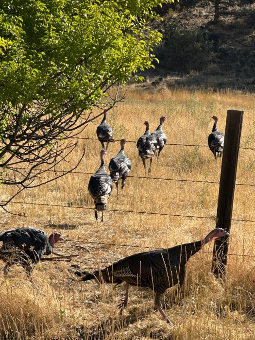
We drove from the Big Bend BLM campground to a small town called Heppner, OR. I had not filled my tank when we left I-84 because it was only 150 miles into the tank and I could go another 300. Well we are lucky we had enough because the truck was at 35 miles estimated remaining when we pulled into the fuel station. Eastern Oregon has a lot of emptiness. We did see a flock of turkeys as we headed up through the mountains.
We did a bit of grocery shopping, so this stop killed our budget for the day. Oh well, we were still heading north back into Washington to visit the Whitman Mission NHS. We did manage to get photos of us crossing the borders. The last two were on freeways and right across a bridge so pics were not an option. Kathy cleaned up the images a bit since people have taken to defacing the signs with stickers.
The Whitman mission site was a location where some Christian missionaries set up to convert the local people, teach them farming and modern methods, and ended up being blamed for not being able to save locals from measles. The local tribe murdered Mr Whitman, his wife Clarissa, and 15 others. This incident started the Indian wars in Washington and ultimately opened the region up to the current day. We hiked around the site and found apples in the orchard and a flock of turkeys walking about. Lots of the signage at this site is negatively written and is a bit of a put off. Hopefully some updates will occur soon.
We headed back towards the Pasco area and grabbed a McDonald’s for dinner. We headed towards Hanford NHS to find a place to camp. The local park campground was closed for the season and we tried three other RV parks, which were more trailer parks. There is a lot of harvesting of apples in this area so I presume spots are filled due to that. We ended up at a Walmart/Home Depot for the night. That parking lot was a bit more active than we would have liked and only two other campers were there. It worked out though and we got a bit of sleep before the landscapers started at 6:30. I was able to get a new eyebolt at HD and some chorizo at Walmart.
The Hanford visitors center is the only early one we have visited. 7:30 it opened. However tours are only in Fri – Sun. Funny thing, we like to get stickers and postcards for souvenirs and they don’t sell them and referred us to a local bookstore around the corner…. Which opened at 11AM. So we made breakfast and hung out until 11. The remainder of the day is driving to the Coulee Damn and Lake Roosevelt.
We got a kick out of a portion of the drive though. We left the plush forests of the coastal rain forests and entered the sparse grasslands and arid forests. We’ve been in green so long that this feels foreign to us now. And while driving the wind turbines are more plentiful than weeds. We can understand the need for alternative forms of energy, but these wind turbines are absolutely atrocious and ugly when driving these back roads. I wish they’d just put up a couple more nuclear plants and get rid of all of this garbage. I think that’s about Adam’s in the background.
Today and the next few days are gonna be 200+ mile days. We have planned to meet up with some friends of ours back in Hamilton, Montana, and the weekend is the best time for them. So today we left Eagle Creek campground and headed to the John Day fossil beds. So the first question I had is who is John Day. There’s a town named after him, several rivers named after him, so he must be pretty important. It turns out he most famous for being attacked by Indian stripped naked and forced to walk 70 miles back to Walla Walla. If you’re interested, here’s some info. https://en.m.wikipedia.org/wiki/John_Day_(trapper)
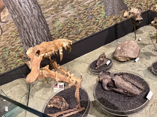
This area of Oregon is actually internationally known. The fossils from 50 million years ago and newer that basically tell us what life was like for early mammals on earth are located here. It’s interesting to see the timetable, with all of the plants and animals 50 million years ago up until about 5 million years ago, when humans first hit the earth. This area is one of the richest fossil beds in the entire planet. The visitor center is phenomenal how it is set up and even has a lab behind a window where you can watch scientists excavate the fossils. We got there slightly before 3 PM and were able to spend over an hour in there viewing and reading the exhibits.
A couple hundred yards down the road one of the old Homesteads is also part of the national park, so we stopped by there to take a look. The site is actually closed to the public, but you are able to tour the grounds. They have orchards back there with tons of apples and pears, and there were signs up that said that we could pick the right fruit from the trees. Having some fresh apples, a snack on will be nice since I’ve been eating too many Oreos lately. I’m going to make a pie in the next couple of days.
We have done so many miles, and I’ve seen so many things on this journey, that we’ve missed a bunch. I would recommend coming to this area and doing some hiking and exploring because there’s so much to see in this area. Maybe at some point we’ll get back here before we can’t move anymore.
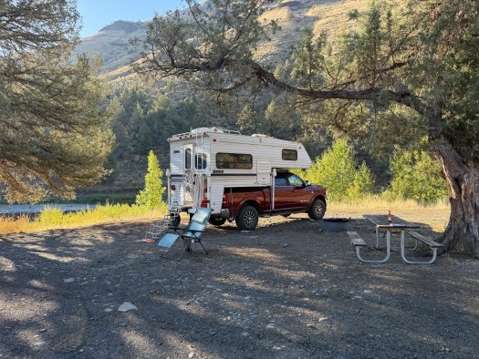
We found a nice BLM campground along the John Day river about 20 miles from the National Park. It’s only five dollars a night and it’s incredibly quiet. I can hear coyotes in the distance and fish jumping in the river. I appreciate quiet and free (or almost free) campgrounds, as there are way too many of those these days. This site is quiet and beautiful and clear.