We camped at Wolf Creek Campground just SE of Whitehorse last night. It’s a Yukon Regional Park official campsite. Every time I camp in a Canadian campground I am impressed. They are far superior to most all campgrounds I have experienced in the US National Parks, BLM, or FS. Tonight $18 CAD (which is about $12 US).
It’s funny because they are not much different except they seem to have more amenities for a lower cost. The camps are easily paid for with cash or with an app. Most have reserved sites and some first come first serve, so there is almost always a site for spontaneous travelers. Some sites have RV dumps and water available as well for free. And they are generally better set up and maintained.
AND there are wood sheds with wood available FOR FREE. US parks often don’t allow wood gathering and require you to purchase it from the camp host, bring it in from home (as long as its not too far so as to no bring in pests), or purchase it from the local store for a $7-10 cost per bundle, on top of the $20-24 campsite fee. A weekend at a US campsite will cost you $50-75 in fees and $50-100 in firewood if you burn nights and morning fires. Plan for a week and that could reach $400. Ridiculous. Everything in the US is behind a paywall, which I could understand for private campgrounds, but these are resources owned and operated by the Gov for the people.
In Canada it’s all included for $18 CAD.
And it’s not free market, IMO, it’s mismanagement of our government resources. What can we do to change this?
We stayed two nights in the ghost town campground of Dyea. This place was home to 5000-7000 folks during the gold rush years of 1897-1898. Along with Skagway, it was the land gateway to the Klondike. Skagway made it due to its deep harbor and the new railroad and roadway connection. Dyea died out and turned to farmland for a while. They tried to build a pier, but with it being over a mile long and still not into deep water, that has also fallen to ruin.
The campground is nice though. Quiet and remote. We did some reading in the nice weather, took a long hike through the trails of the town and gave the dogs some exercise. Kathy and I took an afternoon stroll to the salmon stream and walked in its waters and chased and caught some of the salmon. We had a pretty good couple of days there.
We packed up on Sunday and headed back to Skagway to get a shower at the recreation center. For $10 a day you can get access to the facilities and the showers. It was nice to get cleaned up. We also stopped by the grocery store for some tortillas, creamer, and sodas and then had brunch at a place on the pier that was suggested by the rec center attendant. Kathy had some king crab legs and I enjoyed some fish and chips while chatting with some locals and tourists.
We drove back up the canyon through Whites Pass and crossed back into Canada without the inspection from customs. We may be back in Alaska one more time, but this was the last big visit. It is lived and will be missed.
I was able to contact the old friend we missed in Whitehorse and we met up at Miles Canyon there for a hike. It was a beautiful day and we hiked 3 miles to another ghost town from the early days along the Yukon River.
It was already 7:30 when we set out to gas up, and were able to visit the RV dump and water station as well. We found an awesome campground at Wolf creek right out of town and enjoyed the Canadian Regional park for the night.
I got a call from a guy I met the last time I was in Alaska and he lives in Whitehorse. We had planned on heading to Haines, then catch the ferry to Juneau/Gustavus/skagway for a few days. After looking at the ferry routes, considering the pups on this, and the extra costs, wedecided to reroute a to visit and catch up instead. We got to Whitehorse and tried to meet up. We waited at the local Canadian Tyre parking lot, I walked 3+ miles through the old town, visited a farmers market, and saw some sites. Unfortunately for some reason the meet up did not work out, so we got a sub at Quiznos, drove out of town and found camp just above the Yukon River outside of town and settled down for the night.
One of the things I love about Alaska and Northern Canada is the boreal forests. They have small to medium trees and an always beautiful carpet of moss, lichens, bushes, etc on the forest floor. Wher I grew up in Arizona, the forests are ponderosa pines, some scrub oak, and maybe junipers trees, but the forest floor is generally covered in pine needles or scarce grasses. They don’t have the diversity of life I see here. It is absolutely due to the difference in moisture, and I really enjoy that here. Well, we camped in the boreal forest and it’s so beautiful.
Ok, still not hearing a single response from the guy from the past, we headed towards Skagway. Along the way we stopped at a historic site called Conrad along a glacial valley and lake. Conrad was an old mining village in the early 1900s. A couple of the cabins were being restored, but most had been moved and repurposed to the nearby town of Carnack. I was excited to hike the trails as there were reports of a black bear in the area, but Kathy was not too keen on it.
The drive through this area I believe is more beautiful than the one found to Valdez along the Richardson Highway. In this area there are mirror surfaced lakes, pools, glacial rivers and streams, along a glacier cut mountain top valley. This is berry season and tons of folks are out with their buckets scouring the roadside.
We crossed into the USA and were inspected by US customs who wanted to go through our fridge. We had purchased everything in Fairbanks so the contraband Canadian eggs, meats, or dog food was not present. The last US entry did not seem to care. It may be because we can catch a boat to the lower 48 here, but it seemed odd. Anyway, we continued down the beautiful valley into Skagway.
The valley is famous for the White trail (and the Kilkoot trail in the adjacent valley) during the Klondike Gold rush. In two years over 100,000 people from all over the world traveled through here to get to Dawson City to stake claims. Most turned around once they got there and went home due to finding nothing or not even being able to dig on a claim. These people from 125 years ago were much harder than people from today. I can’t imagine anyone trekking this far in this day and age.
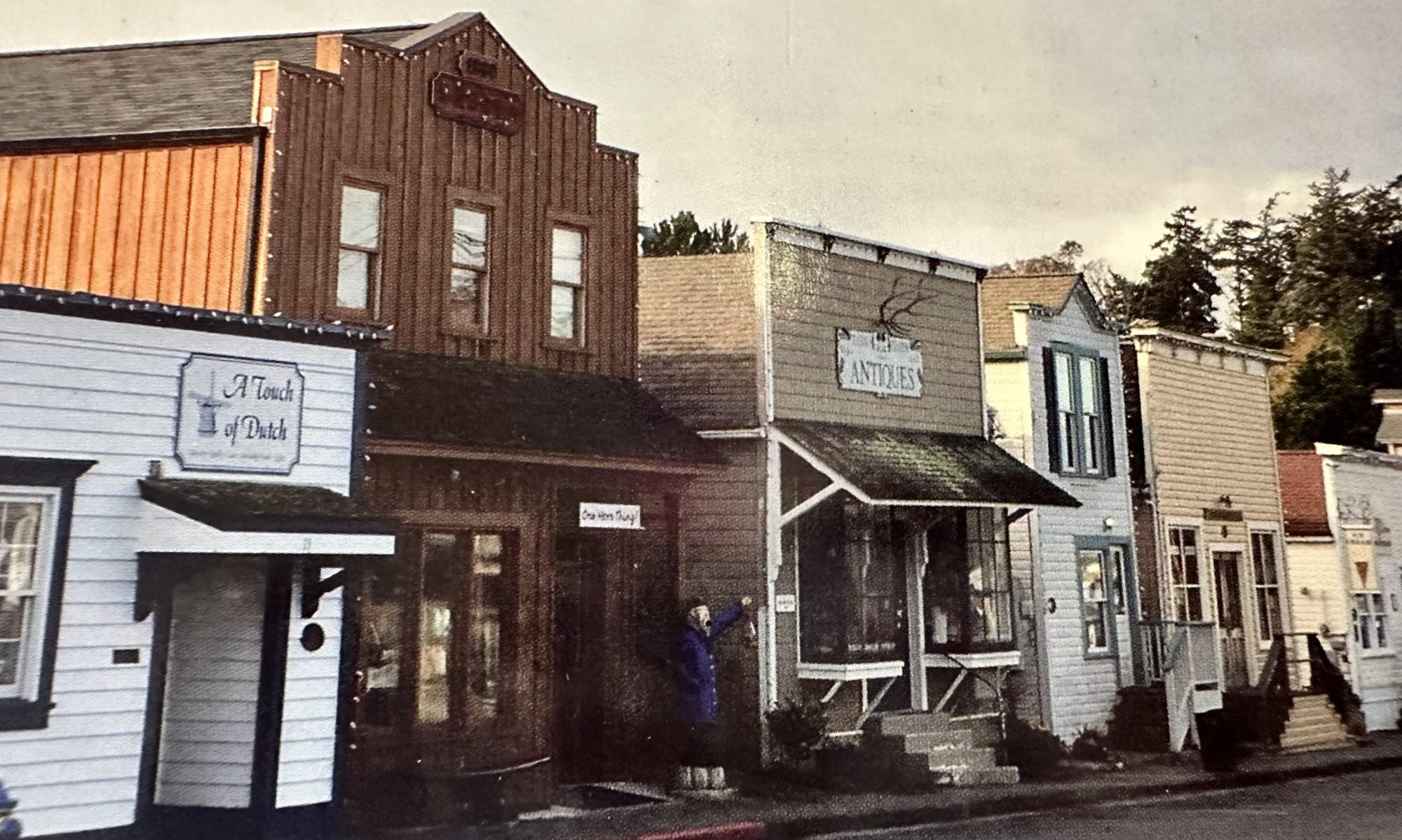
We arrived in Skagway and walked the pups then browsed around town with the cruise ship tourists. They get up to 4 ships a day here and it is crowded. We had a nice dinner at the Red Onion Saloon and Brothel and then headed over tho the Dyea area to camp. I balked at the one lane bridge at the first pass because it showed a 11’5” limit and we are about that. But after testing, it was this at the sides, so we drove right through. We found a campsite and set up quickly. I set out on a hike to the ocean and found lots of salmon, dead and alive, along the stream. It was a warmer evening than recent places.
We drove the 30 miles back up to Fairbanks to pick up Sean’s Rx and then had a nice lunch at a local burger place. We turned Howie south again and drove until about 6 pm on AK Highway 1. There were some beautiful rest stops along the way and we took a few pictures.
We found a nice little campground along the Tetlin National Wildlife Refuge and met a nice couple from Michigan and another from Oklahoma. We didn’t see any big game, but there was a pair of Trumpeter Swans swimming around the lake.
There are lots of road repairs along the highway and several times we waited for pilot cars. I didn’t call it construction because the highway department up here is constantly dealing with road issues related to the seasonal weather. Freezing and melting of the land is not easy on the roads.
We crossed back into Canada on the 20th and continued South. We started to see Fall colors down here as many trees are turning yellow and the shrubs in the forests are orange and red. We found a nice wild beach campsite along Kluane Lake near the Congdon Creek Regional Park in the Yukon. We collected some wood, had a nice fire, and then retreated inside as the rain started. It rained all night. Tomorrow we cross back into the USA and arrive in Haines.
We started the day with a fuel up, a water fill, and a drive to the famous Dredge 4 national historic site outside of Dawson. The thing is massive. It ran for 48 years, the first 30 in the Klondike River and then it was disassembled and reassembled in Bonanza Creek and spent the last 18 years dredging the creek. It averaged 0.5 miles in a season and produced over 300k ounces of gold in its life. Pretty impressive. That’s $18M a year in today’s dollars.
We headed back to Dawson to catch the ferry. The line was pretty long and we waited about 4 hours to get across. It’s nice to have the camper for this. After crossing we began to ascend the Top of the World Highway and the truck has decided to start some diesel emissions issue. Apparently diesels are supposed to be run hard and hot in order to keep the emissions system clean. Problem is the roads here are slow and the fuel is not always great and it has had to regenerate frequently. This time it started a regen and 5 minutes later I get a warning that the DPF is full and I am reduced in power and I have to take it to the dealer. Problem is, nearest dealer is Fairbanks, almost 400 miles away. So we downshift, keep the revs up and trudge onward. I killed the codes I could kill about halfway in and we kept moving. We crossed the USA border, chatted with the guards, and continued on to the Welcome to Alaska sign. Another state on Kathy’s quest. We made it to Chicken and decided to sit for a couple of days and do some research, fix some things, and save some $$. The next part might be costly.
While we were in Chicken, we hiked around and took in the sites, wildflowers, and of course the famous mercantile/bar/liquor store/cafe that is all one building and half sunken in to the ground. We had a few beers and talked with the owner, whose mom used to run the place the past 50 years. The inside of the bar is filled with hats, bras, panties, patches, signs and whatever else might be interesting. The music was played on an old record player and you could choose any vinyl in the collection. Kind of cool.
I took some time to fix an electrical problem we’ve been having with the microwave and then I wired up a more permanent setup for the Starlink. I tried to fix the mount system but it will take some more effort we cannot do here. I instead moved the tie point to the lift corner and left it loose hoping the other 3 will keep it in tact. Kathy took to the camper and truck with the little dust broom and a soft towel and Dry-Washed the road dirt from Howie. 100 miles with rain on that highway really dirtied things up.
Now for the Ram truck. We don’t have much of an option other than drive it as far as we can. It’s 60 miles to Tok, a minor stop on the AK highway, then from there another 120 to Delta Junction. There may be a Diesel Mechanic there. If we make it that far, we’ll try another 100 miles to Fairbanks where there is a Ram Dealer. So wish us luck that it gets us there. We have towing insurance to the nearest mechanic, and hopefully we won’t need it.
The day started for me with a 3-4 mile hike amongst the clouds of mosquitoes around the little lake where we were camped. It sure was quiet and beautiful out there, somewhere in the Yukon.
We got moving around 9 and stopped a few miles down the road to clear some DPF codes on the truck. I met a nice couple from British Columbia who were traveling in a Northern Lite Truck camper. We traded tips and some great conversation before heading back on the road. 15 minutes later I hit a bad frost heave at about 70 kph that was pretty bad. It bent one of my tie downs and pulled the tie down from the camper. Fortunately the repair that the previous owner made held, but I’m going to have to pull the aluminum siding up and fix it right this time.
We got into Dawson about 2, checked in to the El Dorado hotel, and then took the pups for a walk. Maggie darn near dove into the grass at the park to roll. Such a cutie. We put the pups into the camper and headed for some lunch. We ate at the first place we saw and enjoyed poutine and some chicken strips and fries. Food in Canada is $20-30 per plate here. Fortunately they pay regular wages so tips are not required (information provided to us by Canadians in Waterton Lake.
Kathy and I had a chance to do a bit of tourist shopping and sightseeing around town in the afternoon. We had a couple of beverages at a cool saloon called Bombay Bettys. The bar and room were decorated nice and the shaded patio was nice. We showered and freshened up in the hotel and relaxed in the room. Dawson is a cool old town to hang out in.
I got up early and studied the maps to try and figure out an itinerary up until we would be leaving AK. I think I’ve decided to skip the DempsterHighway and do the Dalton Highway. I’ve done the Dempster in 2019 and thought Kathy might like it, but the two are similar, and the PanAm highway traditionally starts in Deadhorse. If we skip it, it will help to get us back on budget, and free up some time to slow down. I’ll figure it out tomorrow since we will be in Dawson City, next to the Dempster.
I took the dogs for a walk and then made some breakfast before we headed out. Kathy and I slept well and were rested. We stopped in Whitehorse, the capitol of the Yukon province and fueled up. We also went into a Canadian Tire store to see what it was like. No food or lumber, but pretty much everything else. We picked up some snacks and supplies at the nearby Walmart and dollar store and continued north. We didn’t see and wildlife at all today, with the exception of ground squirrels and construction.
We stopped at another iOverlander suggested site about 2 hours south of Dawson City. The site is beautiful and quiet. It was raining when we stopped but has let up. It’s good as I wanted to walk the pups. We made hamburgers, mushrooms, and stuffing for dinner.
Since we left Dawson Creek we have ban driving on the Alaska Highway. We left Laird Hot Springs and drove a couple of miles out of the way, up a forest road to the top and next to some radio towers. A storm came in around 10PM and we slept to the sound of rain on the camper.
It was cold when we woke up, about 34 degrees. We made breakfast, packed up and worked our way down the mountain and then northward on the AK highway. We stopped for gas to ensure we made it to Watson lake, and so far this was the most expensive gas, 2.40 per liter. We only bought 10 gallons, which we probably didn’t need. But better to be safe.
While stopped there this guy asked if we were headed north and asked us if we’d take some gas up to a motorcycle rider that ran out of gas. Why not. On the way, we saw a bear eating something on the side of the road, so it delayed his gas by 10 minutes. We did find him at 45 miles up, just as the guy said we would. While waiting for him to refuel, I noticed there were strawberries all over the shoulder of the road. So we stayed and picked a 1/2 pint.
The next major stop was Watson Lake, which houses the Sig post Forest. It started in 1942 when an AK Highway worker put a sign up to bring home a bit closer. It had grown since. I put my license plate up in 2019 while on the trip with Carl Sevier, and after a bit of looking, I found it again. Kathy added her Dawson plate, signed and dated just above it. If you are there and see us, reach out and say hello.
The rest of the day was driving in the rain and we made it to Teslin Lake around 5. We made camp at an IOverlander suggested spot on the edge of the lake with stunning views of Teslin lake. It started raining again and we slept soundly.
We drove the 255 miles today to Laird Hot Springs through some more forests and then some breathtaking mountains. The day was filled with wildlife. First a moose and her calf, then a Canadian Lynx, then some Big Horn sheep and their kids, and a herd of buffalo and their calves, and two bears wrestling along the road, and finally some cute squirrels. The 5 hour drive was beautiful.
Laird Hot Springs campground was full and we had the option to pay for a spot in the overflow lot. Nope, just paid to use the hot springs, then used their picnic area to bbq some chops and potatoes for dinner. We used iOverlander to find a spot, but the past few days the trees and lack of cell service hindered calls, etc. So we found a top of the mountain spot with amazing views.
We left Oscar at the vet to be cremated and will be back to pick his ashes on the way back down. We had planned two nights in Grande Prairie but after saying goodbye, we fueled up, filled the fridge, and headed to Dawson Creek to Mile 0 of the Alaskan Highway to start the next section fresh.
We took the tourist pictures, walked the pups around downtown, and then visited the museum. We found a nice R.V. park just outside of town and got the planned laundry done and headed to bed early. Neither of us had much sleep last night.
The night was rainy and windy but Howie was quiet and warm. We headed out first thing in the morning up the Alaskan Highway. The highway to Fairbanks is 1525 miles. The route we are taking is 1200 miles to Dawson City. So it’s not a quick run, considering the top speed is 100KPH (62mph). We are doing 200-300 mile chunks. Today we headed to hit Prophet River Wayside Park, about 225 miles.
There is a whole lot of forest on this highway as well as some recent forest fires. One from last year was massive and took out an entire valley for 30 miles. Pretty sad.
We arrived around 4 and made camp. There was a family from Mexico camping there with a YouTube link so I looked them up. They were live broadcasting. At the time so I sent them a note we were camped next to them and would say hello. David and Ixchel are Mi Casita Nomada and they have been traveling since 2023. I talked to them for about 20 minutes and we wished them well. We may run in to them again.
Some other campers at this site were dressed up in some strange outfits and hanging from a board between trees, so I had to ask. The group were training for skydiving and extricating themselves from trees. They were getting on a plane in the morning and skydiving into a remote river location and then rafting down the river.
We later took the pups for a walk and relaxed for the evening. I found some raspberries and wild strawberries near the Prophet River. We miss Oscar and both went to sleep around 9 and slept a full 11 hours. Tomorrow is Liard Hot Springs.